Pages

Tuesday, October 26, 2010

A Hike and a Visit to the Deserted Swansea Copper Mine

Yesterday was another beautiful day. We slept again last night with the windows open and had temps in the upper 60's. With the windows open we've heard the coyotes in and around our rig. This morning we found coyote scat about 12 ft from our front door. We're guessing the two we photographed for a previous blog may be with the culprits.
Yesterday morning we decided to take a hike. You see there's this big mountain, a part of the Buckskin Mountains that is in front of our rig that has been calling out to us to hike it ever since we got here!
It's actually across the cove from us. You may be able to barely make out the dirt road beginning at the bottom left of the photo. Anyway this dirt road is used to service the power lines. It's a very steep and rocky road and I've never seen anything drive up but I have seen a jeep come down the road. It's actually off-limits to vehicles with the exception of the power company. Well, yesterday the weather was right with cool temps and overcast skies so Joyce and I decided it would make a nice hike up to the highest power line.
Like I said it's a very steep road and this is one of the better sections. We needed to stop several times along the way to catch our breath!
The views from the top are spectacular. Below you can see the Bill Williams River National Wildlife Refuge compound which contains the administrative building, visitor center, fleet yard and our host sites. The thin peninsula includes the paved nature trail and fishing piers.
In the picture below the green cattails in the upper right (over Joyce's shoulder) is the confluence of the Bill Williams River into Lake Havasu.
It took us about an hour round trip for this hike from our host site. You can just make out highway 95 and the bridge over the river on the right side of the photo below. The majority of the refuge is to the right of the highway paralleling the river.
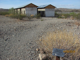
Later in the day we took a ride out to an abandoned mining townsite known as Swansea
Mining in the Swansea Area began around 1862, but major activity had to wait for the coming of the railroad.  In 1904 the Arizona & California Railroad began constructing a line from Wickenburg to Parker.  Seeing an opportunity for further development several of the original miners, Newton Evans and Thomas Jefferson Carrigan, secured investment money and began to develop Swansea.
The trip was 50 miles one way and 17 miles of that was on primitive dirt roads. It's nice to have a Jeep!
By the end of 1908, a 350 ton capacity furnace, a 3.5 mile water pipeline from the Bill Williams River, and the hoists for five mine shafts were under construction. By 1909 Swansea had a population of 500.  The following year the Arizona & Swansea railroad began operation from Bouse.  The railroad was key in moving supplies and people in and out of the growing mining town.  Financial problems set in by 1911 and the mines shutdown with a brief reopening in 1912. The American Smelting and Refining Company bought the mines in 1914 and rebuilt much of the town.  The new owners ran the mines until 1937 when the Great Depression closed the mines for good.
There wasn't a lot to see in the abandoned mining town. Just some building and mine shaft foundations. There is a self-guided walking tour and we walked a portion of that before getting bored.
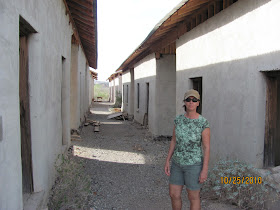
Below are the worker's cottages. The roofs and gables are being restored.
Each of the small rooms are about 10 ft by 10 ft with only a window, a door and a dirt floor.
Little remains in the town from the glory days of Swansea.  The townsite has suffered from the weather and vandalism in recent years.  You can still see several adobe and brick buildings, the railroad grade, numerous foundations, and the mine shafts.  The open mine shafts and tunnels are dangerous and should be avoided.
Before long we called it a day and headed back home enjoying the scenery of the desert on the long dusty ride back.

Sunday, October 24, 2010

Another Hike in Sara Park

October 24, 2010 Bill Williams River National Wildlife Refuge.
Yesterday, we started our 3-day off cycle and awoke early to this view of the moon outside our rig. The weather has been gorgeous with temps in the 60's in the mornings and highs in the low 80's. 
A couple of days ago, Joyce and I had been talking to Mitch,  just one of the U.S. Fish and Wildlife Service Biologists that has an office here at the refuge.  Mitch told us that he would be hiking down into The Grand Canyon on Monday to do a fish survey in the Colorado River. That peaked our interest and we soon began discussing his adventures in the Canyon as he has hiked in and out a few times but, it had been a while since his last trip. Before long, Mitch invited us to go on a hike with him at Sara Park. You may recall Joyce and I hiked in Sara Park a few weeks ago. However, there are a number of trails in the park and we planned on returning. Subsequently we accepted Mitch's invitation and made plans to meet him at 8:00. 
We all showed up on time. Mitch brought along his two constant hiking companions, his dogs. As it turns out we later learned that Mitch has been hiking this particular trail nearly every day for 6 weeks in preparation for his trip back to The Grand Canyon. 

Mitch and his dogs
Joyce and I showed up overdressed as this was a fast paced hike up the side of Picnic Table Mountain. 

Much of the trail on the side of the mountain was narrow, rocky and slippery as some of the trail had been washed away by the recent rains. We were hiking in Big Horn Sheep territory and Mitch pointed out potential areas were the sheep would bed down as we climbed the side of the mountain. We certainly enjoyed the views that sheep enjoy along the steep rocky cliffs. But to be honest I spent most of my time concentrating on my next step! Mitch just took it all in stride confident in his abilities and knowledge of the trail.

Lake Havasu City in the distance
From high on the cliff we could see this lizard outlined on the ground below with rocks. I zoomed in with my camera for this picture. Mitch told us that it was created by a local hiking club, The Leaping Lizards.

Leaping Lizard
Joyce and I stopped for this photo opportunity taking advantage of the break to catch our breaths! I know...I need to get rid of the straw hat and find a real hiking hat! We would have been better off in shorts and hiking sneakers instead of our pants and boots.

Getting down from the side of the mountain was another challenge. As we came down the narrow switchbacks we had to slide and jump down some 5 ft. drops. Keeping our balance was essential to keep from tumbling down the side. Most of the hike and particularly keeping up with Mitch was too arduous to allow for much picture taking. However, we thoroughly enjoyed the hike. I know that this hike with Mitch pushed Joyce out of her comfort zone but she pushed on like a trooper. I'm glad Mitch was with us as I don't think we would have done that trail without an experience hiker leading the way!
We had a great time and plan to return to Sara Park to take on some of the more challenging trails with a renewed since of confidence.

Thursday, October 21, 2010

Rain at the Refuge

October 21, 2010 Bill Williams River National Wildlife Refuge


The last couple of nights and early this morning, we got some much needed rain here at the refuge. October is the start of the rainy season.

Along with the rain has come a marked decrease in temperatures and a return of the flies! The last two nights we've been able to turn the A/C off and fall asleep to the sound of the thunder and rain.
Out on the refuge on Planet Ranch Road we even had mud puddles!
Yesterday, the Assistant Refuge Manager, Stan and I mixed and poured a 14 ft. concrete slab against the connex tool shed. The slab will be used to house some flammable material metal lockers. We used a mixer attached to a Bobcat and 16- 60 lb. bags of cement.
First thing this morning we were working and saw two young coyotes that have probably recently separated from their mother.

This one decided to snack on one of the many drip lines feeding off the larger main pump lines.

They finally moved off as we got closer. The sad part is that they don't seem to be too shy as you wouldn't normally see coyotes lingering out in the open. I'd guess that I took the photos at about 50 yards.
Later in the morning, Joyce went out with one of the Fisheries personnel to get an estimated count of American Koots and other birds in the preserve. They estimated over 5,000 birds near the confluence of the Bill Williams River and Lake Havasu. 
When she got back, we drove a refuge truck into Lake Havasu City to unload 4 old 6volt batteries at a battery shop. I was surprised to learn that the batteries weigh 62 lbs. each.  As you may recall, I've had to replace several of these batteries including 8 at one time in one of the John Deere Electric Gators. I knew they were heavy, but now I know why my back was aching afterwards. 
In and around town, we've notice a dramatic uptick in traffic. We see lots of RVs driving on the highway usually headed south. Today we say hundreds of old restored cars and trucks driving around. There's a big car show tonight in Lake Havasu City.
We'll see what tomorrow brings...

Tuesday, October 19, 2010

Clearing an ATV Trail in The Refuge

October 19, 2010 Bill Williams River National Wildlife Refuge.
Yesterday I met the Assistant Refuge Manager, Stan Culling bright and early at 0700 for our planned excursion into the refuge to clear and widen one of the ATV Trails.  Although it was overdue, we were doing it so that the power company could get through to move and install power poles.
Joyce also got up early and made us some awesome breakfast burritos. After we consumed the burritos and fixed the parking brake on the Polaris Ranger, we were soon ready to roll. It was an overcast morning and slightly humid, but not Florida Humid!
We drove out Planet Ranch Road parked and then drove the Polaris off the trailer. We continue down the road and past the locked gate for the ATV road which at one time was an extension of Planet Ranch Road. However in the past decade, there have been some flood events in the refuge that wiped out Planet Ranch Road making it unrecognizable and impassable. That resulted in the decision to gate it and block access to the public by vehicle. Only Refuge vehicles/ ATVs are permitted now.
Stan and I brought with us a pole chain saw and regular chain saw. We got to work immediately cutting everything in our path. The sandy soil made it difficult to walk as we carried the saws dressed in heavy chaps.
We drank a lot of water as we made our way down the trail. Most of what we cut was the invasive Salt Cedar Trees although we did have to tangle with a few thorny Mesquite Trees as well. 
The flood events I previously mentioned filled the underground aquifers and brought the water table up to such a level as to sustain these trees in the low lying areas of what used to be desert landscape. Walk just a few hundred yards out and you are back to a more typical desert.
By noon we were both exhausted with heavy arms from wielding the chain saws. We headed back and unloaded satisfied, that we had cleaned up about two miles of trail.

Saturday, October 16, 2010

Busy work days and Catching Up

Joyce and I have been busy the last few days working here at the refuge. Last week Joyce and I spent a lot of time filling,testing and replacing some of the 80 plus 6-volt batteries  used to support the solar power systems around the refuge complex. This week we started our 3 day rotation with our daily cleaning of the paved trail and the fishing piers. We noticed the piers had not been pressure washed since the last time I had done them and they were filthy. With the cooler weather, we are seeing more visitors and fisherman using the piers. So we cleaned them up as well as we could with the plan to pressure wash them a day early..tomorrow. Each of the two volunteer couples is suppose to pressure wash the piers on the last day of their rotation.
Stan the assistant refuge manager, had an urgent mission and needed us to run into Lake Havasu City and pick up materials to repair a broken water line leading from one of the lake pumps. The refuge pumps its own water out of the lake into a very large cistern. The water is then treated with chlorine and filtered via a reverse osmosis system. There are two pumps set up for this task. However, one of the pumps has been disabled for a few weeks due to the broken line. 
Joyce and I drove into town and picked up the pvc pipe and pieces I would need to make the repair. After returning, I flushed the broken pipes and then cut about a 6 ft piece of PVC 1 inch pipe, attached hose barb fittings and clamps and made the repair.
We enjoy working for/ with Stan. as the Assistant Refuge Manager, he’s in charge of managing the volunteers (us) and getting tasks accomplished on the refuge. Often Stan makes a list of projects for the volunteers to accomplish on an erasable board outside of his office. I have to tease him sometimes as it takes more time to write some of the tasks on the board than to just do it..ie. test the smoke detectors in the building. 
The 2nd day, we did our daily trail chores and pressure washed the two aluminum fishing piers. We later accomplished a few other minor tasks before we again drove the refuge truck into Lake Havasu City to exchange some locking gas caps for the refuge vehicles. Locking gas caps had been purchased but the two we exchanged didn’t fit. The NAPA store only had one gas cap and we needed two so we would have to return again the next day! Then we drove to a Bobcat dealer to pick up a part for the refuge’s machine.
Later in the day, Stan mentioned that he could use some help clearing the invasive Salt Cedar Trees and overgrowth that is covering one of the ATV roads out in the refuge.
Yeah, this road needs to be cleared out!
Knowing it would be my scheduled “day off” he didn’t want to bother me with it. However, the power company is working to install new power poles through the refuge and they need access through the ATV road. The power company wants the refuge to clear the road. So, I volunteered to assist Stan on my day off...this coming Monday.
Subsequently, Stan and I spent the afternoon trying out the new pole chainsaws he bought for clearing the road. What that really means is that we did a lot of cutting and clearing around the compound. Safety rules dictated that we wear hard hats and orange kevlar chaps when working with the chain saws.  It was only 98 degrees that day! I was soaking wet with perspiration when I got home. 
Today, Joyce and I again cleaned off the paved trail, fishing piers and collected the garbage. Joyce then cleaned the offices and visitor center while I cleaned up some of the invasive Salt Cedar Trees that Stan and I had cut down yesterday around the compound. There is a large brush pile on the compound that has more than doubled in size since Joyce and I arrived over a month ago. 
We usually open the visitor center from 10:00 till 2:00 when we are scheduled to work on the weekends. However, we had to get back to Lake Havasu City to pick up one of the new Pole Saws and a chain saw before the shop closed at 1:00. You see yesterday, one of the pole saws was dulled when it wouldn’t cut through a rock! (Not me). So Stan dropped it off for repair on his way home. Therefore, we closed the visitor center at noon. So it has been three days in a row that we’ve had to drive a refuge vehicle into Lake Havasu City. I told Joyce today that I was getting bored with the drive. It’s about an hour and a half of driving round trip. The good thing about taking the refuge vehicle to town is that we are permitted to run personal errands in town in their vehicle if we are in town on official business. They also want us to drive the National Wildlife Refuge vehicles in some of the remote areas of the refuge so that the public sees a presence of official vehicles and staff.
I think that pretty much brings us up to date. We still have internet connection issues due to the spotty Verizon Coverage here at the refuge. So it really makes it difficult to post daily.
Next week is suppose to bring much cooler temps in the upper 80's and low 90's. 

Tuesday, October 12, 2010

Our Visit to Oatman, Arizona

October 11, 2010, Bill Williams River NWR
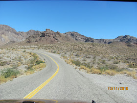
Today we took a long ride out to Oatman, Arizona in the northwest corner of the state. The ride took us along Historic Route 66 from I-40 north. We were both surprised that Route 66 was so narrow, twisty and hilly. In fact there were signs indicating that trucks over 40 ft. were not allowed. 
It's a beautiful drive through the desert. After about 80 miles of driving from Parker, Az we finally arrived at Oatman and the tiny visitor center on the outskirts of town. After getting a little history lesson we found a place to park our Jeep on the north end of main street in the quant old town and began our walking tour. This leg of the former Route 66 is now called Oatman Rd., the main street through town.
One of the first things you see are the Wild Burros standing in the street. In fact when driving through town we had to wait till the burros let us pass. Oatman is famous for the burros.
Oatman was once a gold mining town. The town has a rich (in gold) history to include a fire in 1921 that destroyed many of the original buildings. Shortly thereafter the largest mine near the town shut down and by the 1940's all the mines were shut down. Oatman was able to survive however by catering to motorists and tourists because fortunately for the town, Route 66 passed through the center of the town. This kept the town alive till the early 50's when Oatman was bypassed by Interstate 40.
Oatman nearly died once the interstate opened. However, enterprising parties turned the town into a tourist attraction thanks to the wild burros that frequent the town for handouts and the renewed interest in Historic Route 66.

Built in 1902, the Oatman Hotel survived the fire of 1921 and is the oldest adobe structure in Mohave County. We ate lunch in the hotel on the first floor in a room with dollar bills stapled all over the walls.
Although "wild" the burros appeared to be very tame as they walked up on the porches and pressed visitors for treats of carrots. Most of the shops sold burro treats. The burros are not shy and will trot up to you and check your purse and / or pockets if they think you have treats or anything in your hands.
Looking down Historic Route 66 from the perspective of a burro.
The story goes that the burros are descendants of those belonging to the old miners that were let loose after the mines closed. 
After leaving Oatman, we continued north and east towards Kingman on Historic Route 66 again enjoying the twisting switchbacks of this scenic road as we climbed to Sitgreaves Pass at 3550 feet before descending towards the valley and Kingman, AZ.
From Sitgreaves Pass looking southwest towards Oatman
Just before reaching Kingman we jumped on I-40 West and then turned south headed back towards Parker, AZ and the Bill Williams River NWR. It was good long drive and worth the trip!

Wednesday, October 6, 2010

Wild Burros and Our Sara Park Hike


October 6, 2010. Bill Williams River, NWR
I'm finally able to update my blog with pictures after my 20 gigabyte upgrade to Picasa Web took affect. You may recall that Picasa Web is the site used for storing Google Blogger photos.
I had wanted to upload in the previous post, pictures of this Wild Burro (donkey) we saw on the side of the road near the Parker Dam (on the California side of the Colorado River).
Wild Burros feed on a variety of of plants, including grasses, Mormon Tea, Palo Verde and Plantain. Although some moisture is provided by these plant materials, Wild Burros must have drinking water throughout the year. They can usually be seen foraging for food during daytime, except for summers, when they will forage only at night and in the early morning.
Wild Burros range through a wide variety of desert habitats as long as they are within 10 miles of drinking water.
This area on California Hwy 62 is known for the Wild Burros that roam the mountains and come down to the road for treats of carrots and apples from motorists. We saw a group of four up on the hillside today while out for a drive.

Yesterday, the weather was absolutely beautiful with a morning low of 70 and a high of 85. We decided to take a hike in Sara Park which is just south of Lake Havasu City. 


The park is full of various trails. The main trail is through a wash leading to a narrow slot canyon.

The further down the wash you travel the narrower it gets. Large rocks block the path requiring some scampering and stretching! This area of the park is known by the locals as Sara's Crack due to the narrow slot canyon and pink coloration. Just use your imagination!

At one point our forward progress was halted by this 8 ft drop. Apparently some hikers slide down the rock. However, it's very difficult to get back out this way. I was told that at this time of year it's possible to kinda get stuck if you decide to slide in. Although hikers can normally continue to hike out of the canyon further in, there could be standing water up to chest deep that hikers would have to get through to get out. This area had heavy rain just a couple of days ago!

So, we turned around and climbed up a trail over the side of the canyon for this great view of Lake Havasu.
After a few hours of hiking it was time to head back to the Jeep and then into town. We had a great time at Sara Park and plan to return and check out some of the other trails another day.