Lake Mead N.R.A.

Lake Mead N.R.A.
READY TO ROLL!

Monday, December 12, 2011

Holidays at Lake Mead N.R.A.

Lake Mead National Recreation Area.

Wow! It's been a while since I last posted. We've spent the last few weeks working at our volunteer job driving and checking out the back country roads. We've also managed to do a few hikes within the park with Paul and Paula and some other volunteers Laura and Sasha. One of the prettiest hikes was a 7+ mile hike in White Rock Canyon

On a hike with Paul, Paula, Sasha, Joyce, Laura and me.


One of our work days took us back to Christmas Tree Pass. As you may recall we had been out there in the middle of a snow storm that had forced us to turn back. The drive over Christmas Tree Pass was beautiful as we entered Lake Mead N.R.A. from the BLM.


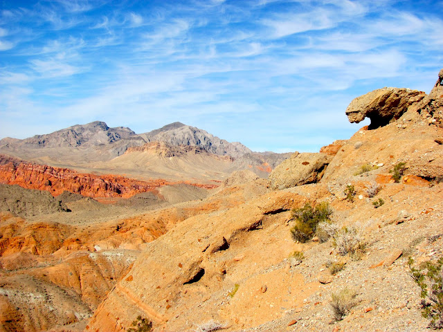
We did a short hike off North Shore Drive in Lake Mead N.R.A that gave us these beautiful views of the rugged red rock terrain. This part of the park is near the Nevada State Park, Valley of Fire.


Time has flown by! Christmas has come and gone and we look forward to the New Year. During the Christmas holiday, we left our fifth wheel in the volunteer park and drove to Mesa, Az. to visit with my Father and Karen. It was a nice drive in the truck of about 320 miles each way down highway 93 passing through the Joshua Forest. We had a very nice stay and enjoyed our time in Mesa. We also enjoyed a family get together and tamales at my cousin's home.
Christmas Day party at the home of Cousin Terry and Rick
Our supervisor, Dara has been very generous with allowing us to have time off for the holidays. It appears that most of the staff is gone for the holidays.
Las Vegas is expected to put on a spectacular fireworks display. So  for New Year's Eve, Joyce and I plan to find a good overlook of the city skyline and watch the fireworks.

We hope that all of you have a safe holiday and a Happy Prosperous New Year!


Saturday, December 3, 2011

4th Week Volunteering at Lake Mead N.R.A.

December 5th, 2011 Lake Mead National Recreation Area.


At the start of our 4th week of volunteering at the park we began with some inclement weather. Two cold fronts pushed through. The fronts produced some rain and windy cold conditions. Joyce and I reported to our volunteer job on a rainy cold morning, ready to drive our assigned back country roads checking for disturbances, off road incursions and damaged barriers. One of the staff members suggested we change our assigned roads for the day due to potential flash floods.  So on their suggestion we were assigned to drive Approved Road (AR) 20 in the park just south of Searchlight Nevada about 60 miles south of Boulder City. Driving south on Highway 95 we encountered snow along the highway as we gained elevation above 3000 ft.
Joshua Tree in the snow 
After passing through Searchlight, NV on Highway 95 we turned onto a BLM road, Christmas Tree Pass Road and drove east towards the park boundary.  Hmm.. the fact that the name of the road had the word Pass in it should have been a clue.
BLM road leading to Christmas Tree Pass
As we continued east towards the park boundary, the snow got thicker as we again were above 3000 ft. in elevation.
Snow in the high desert
Before long we found ourselves in an active snow storm and the road was quickly covered in snow. Because we weren't familiar with the road and the snow was making it impossible for us to look for "disturbances" let alone see the road, we decided to turn around and head back and work on some roads at lower elevations.  However, it sure was beautiful to watch it snow in the desert!
Throughout the rest of the week we gave the park's Chevy 2500 Diesel a workout. 

We traveled through sandy washes and over rock debris filled roads some barely wide enough to fit the truck.


The road below was particularly challenging. Although it's not real evident in the picture, the road AR 70A follows along the top of a ridge line with numerous hill tops. The truck we were driving sits high making it impossible to see the road as we came over the tops of the hills making it challenging and nerve racking as the road drops off on both sides. Often Joyce had to jump out to guide me as I couldn't see the road. Making it worse, the road was littered with eroded holes in some spots.
Highway 93 in Arizona in the distance near  the Hoover Dam. AR70A follows the ridge to the left.

Driving the back country roads can be fun and challenging but it's also exhausting as we get bounced around for 6-8 hrs. each day often crawling along on rocks at less than 10 mph. On our final day of our rotation, we were assigned a road named Detrital Wash well out in the back country on the Arizona side of the park. Well, for sure it was in a wash area  and the road itself was washed away. Without the GPS, Joyce and I wouldn't have been able to determine where the road was supposed to be. The sand was deep and eroded and we eventually had to turn around and just drive out the way we came in for fear of getting stuck in the sand out in the middle of nowhere. 

Friday, December 2, 2011

Historic Railroad Trail

December 5, 2011 Lake Mead N.R.A.
\
Inside the park from the Boulder City entrance and just before the fee booths at Lake Mead Recreation Area is a parking area for the Historic Railroad Tunnel Trail head.  It's a hike/ bike trail that follows part of the route that the railroads used to build the Hoover Dam.
Heading up to the tunnels to the left from the trail head parking lot
It's a gravel/ dirt trail that goes through 5 tunnels. It's only 3.7 miles from the trailhead to the dam parking lot.
A succession of two trails
The best thing about the trail is the beautiful views it provides of Lake Mead.
Lake Mead marina
Historic Railroad Tunnel Trail
family hiking through tunnels
Family hiking through railroad tunnels
Time Line & Facts
  • 1931: Lewis Construction Company began construction under Bureau of Reclamation.
  • 1961: Last year railroad in use.
  • 1962: Tracks dismantled and sold for scrap.
  • 1984: Nominated to National Register of Historic Places.
  • Length: 3.7 miles from trailhead to Hoover Dam Parking Garage. 
  • One of two most difficult sections of track to construct.
  • Only remaining section of Hoover Dam Railroad system that is not highly disturbed or under water.
  • All tunnels are approximately 300 ft. in length, and 25 ft in diameter. The tunnels were oversized to fit penstock sections and large equipment being transported to Hoover Dam.
  • Nine steam and four gas locomotives and 71 people were used to operate the system. It was a standard-gauge, 90-pound rail construction that used Oregon fir ties.
  • This section was used in the motion picture "The Gauntlet" starring Clint Eastwood and Sondra Locke for a sequence in which they were on a motorcycle being chased by an assassin in a helicopter.

Joyce emerging from one of the 5 tunnels.
From the trail head parking lot the trail would only give us about 7 miles of bike riding. I wanted to ride further so, Paul rode with me from our campground to the trail head and Joyce rode back to the campground with me from the trail head for a total of about 17 miles. Riding up to the trail head there is a long grueling 8% grade on the bike path. However, it makes for a very fast return trip!
Bike path in the park.
We enjoyed our little excursion to the Historic Railroad Tunnel Trail. It seems to be a very popular stop for the locals and it sees a lot of use. It's worth the stop if you have the time and need a scenic hike or a short bike ride.