March 16, 2010.
We awoke with the full intention of traveling towards Austin, Texas. However, the weather report last night was not inspiring and it was cloudy this morning. We checked the local weather which indicated a slight chance of rain for Louisiana. I then checked the Weather Underground website and discovered that most of Texas and particularly the area we would be traveling in was covered in rain with 80% chance of rain all day.
Now you gotta remember, We are retired and not in a hurry to get anywhere! I'm certainly not going to tow my house (fifth wheel) in foul weather when I have the option to avoid it. Not only is it risky but, rain and wet roads make everything filthy when you drive! So, we walked Maggie and Rico to the office and extended another day at A Plus Motel and RV Park.
By late morning, it was raining and continued lightly raining here in Sulphur, Louisiana. We could see the pollen pooling in the the rain run-off. As much as I wanted to move on, I felt confident we made the right decision to wait another day.
We spent most of the day enjoying the park's WiFi and staying dry. Hopefully tomorrow we will be 'on the road again'.
Lake Mead N.R.A.

READY TO ROLL!
Showing posts with label Louisiana. Show all posts
Showing posts with label Louisiana. Show all posts
Wednesday, March 17, 2010
Tuesday, March 16, 2010
Spare Tire, Lauberge Du Loc, Ready to move on
March 15, 2010. Happy Birthday Rocky!
The day started out bright and sunny with temps in the 50's quickly warming to the upper 70's.
We had noticed these mud towers in the field next to us.

Rico seemed to have a special interest in these mud towers and I was curious as to what created them.
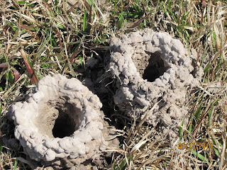
It turns out they are created by crawfish a.k.a. crawdads. I learned the following via the internet: In areas where water dries up, crawfish build mounds of mud that look like little towers. If you live in southern Louisiana you usually see little mounds close to ditches. This is where crawfish stay until the water comes back. It is also where the female crawfish go to lay eggs until they hatch.
Joyce decided it was time to do laundry, so she took care of that at the laundry room in the park.
I needed to check the air pressure in the spare. The spare is mounted underneath and held up against the bottom of the fifth wheel. I assembled the pole and crank handle and attached them to the crank bolt in the rear basement of our Carriage Cameo. I then lowered the tire by rotating the crank counter-clockwise.

The spare tire was mounted so that the valve stem was facing up against the bottom and thus not accessible. So I needed to drop the spare tire to flip it around. It's held by a cable and "T" shaped piece of metal.

I pulled the tire out, checked the air pressure which was 76 p.s.i. and aired it up with my compressor to 80 p.s.i. I then remounted the spare tire so that I would have access to the valve stem!
In the afternoon, we took a trip out to Lauberge Du Loc a casino nearby off I-210 in Lake Charles.

Now don't worry, we didn't adorn ourselves with good luck charms and or rabbits feet. Even though it's our second casino in less than a month, we aren't becoming professional gamblers. Perhaps just as bad, we put on our loose clothes and headed out for the all you can eat buffet!

At $13.95 each the buffet was a great deal. They had an assortment of foods, to include American, Asian, Mexican, seafood and all types of desserts!

We ate till we were ready to burst after fasting all day. Later we walked outside and around the first floor of the casino. The casino is located on the Calcasieu River. This Barge was just outside.

The I-210 bridge is behind Joyce in this picture. She was happy as she was wanting to go the buffet for the last couple of days but, I wasn't up to it. She really enjoyed the crab legs.

A nice arrangement in one of the many lobbies.

We cruised through the actual casino. I couldn't handle all the cigarette smoke!

We got back home around 5:30 and because of daylight savings, we had plenty of daylight left. We had extended our stay to receive our forwarded mail from our mail service American Home Base. Our expected mail arrived today so we are planning to move on tomorrow towards Somerville Texas on our way to Austin Texas.
I made some preparations to leave to include my routine checking of the air pressures and putting my transponders on the fifth wheel valve stems for my tire pressure monitor system.
I researched some campground possibilities along our route. I spoke earlier in the day with a state park employee who indicated that they are in their peak season for campers coupled with the fact that Spring Break is underway. So we hope we won't have difficulty finding a new site!
The day started out bright and sunny with temps in the 50's quickly warming to the upper 70's.
We had noticed these mud towers in the field next to us.


Joyce decided it was time to do laundry, so she took care of that at the laundry room in the park.
I needed to check the air pressure in the spare. The spare is mounted underneath and held up against the bottom of the fifth wheel. I assembled the pole and crank handle and attached them to the crank bolt in the rear basement of our Carriage Cameo. I then lowered the tire by rotating the crank counter-clockwise.

The spare tire was mounted so that the valve stem was facing up against the bottom and thus not accessible. So I needed to drop the spare tire to flip it around. It's held by a cable and "T" shaped piece of metal.

I pulled the tire out, checked the air pressure which was 76 p.s.i. and aired it up with my compressor to 80 p.s.i. I then remounted the spare tire so that I would have access to the valve stem!
In the afternoon, we took a trip out to Lauberge Du Loc a casino nearby off I-210 in Lake Charles.

Now don't worry, we didn't adorn ourselves with good luck charms and or rabbits feet. Even though it's our second casino in less than a month, we aren't becoming professional gamblers. Perhaps just as bad, we put on our loose clothes and headed out for the all you can eat buffet!

At $13.95 each the buffet was a great deal. They had an assortment of foods, to include American, Asian, Mexican, seafood and all types of desserts!

We ate till we were ready to burst after fasting all day. Later we walked outside and around the first floor of the casino. The casino is located on the Calcasieu River. This Barge was just outside.

The I-210 bridge is behind Joyce in this picture. She was happy as she was wanting to go the buffet for the last couple of days but, I wasn't up to it. She really enjoyed the crab legs.

A nice arrangement in one of the many lobbies.

We cruised through the actual casino. I couldn't handle all the cigarette smoke!

We got back home around 5:30 and because of daylight savings, we had plenty of daylight left. We had extended our stay to receive our forwarded mail from our mail service American Home Base. Our expected mail arrived today so we are planning to move on tomorrow towards Somerville Texas on our way to Austin Texas.
I made some preparations to leave to include my routine checking of the air pressures and putting my transponders on the fifth wheel valve stems for my tire pressure monitor system.
I researched some campground possibilities along our route. I spoke earlier in the day with a state park employee who indicated that they are in their peak season for campers coupled with the fact that Spring Break is underway. So we hope we won't have difficulty finding a new site!
Monday, March 15, 2010
Under the Weather
March 13-14, 2010.
Yesterday March 13, I was a bit under the weather but we decided to take a spin into Lake Charles and have a look around. It was a beautiful sunny if not windy day. We took I-210 east and drove over this rather high bridge under repair.

We went in search of the historic district and came upon this old city hall building and this beautifully restored home.


After a bite to eat at a local diner, we went back home. The rest of the evening, I was feeling worse from this cold. I went to bed early.
March 14,
With daylight savings time, I slept till noon as Joyce took care of Maggie and Rico. I hadn't slept well the night before with all the coughing etc. So I took advantage of the opportunity to sleep in.
I got out of bed feeling better and made us a late brunch out on the grill in the very bright warm sunshine. We talked with some of our neighbors and made plans for the rest of our stay. Then before we knew it we were both taking an afternoon nap. Temps. were in the upper 70's.
After I got up from the nap, I fueled up my truck and manually figured the mileage from our last trip. 222 mile @ 10.5 mpg. I think that was pretty good! Then I took it to a carwash outside the park and gave it a good cleaning before covering it up. There's been a lot of pollen in the air and it settles on the vehicles.

Next it was time to wash Joyce's car. I cleaned it up good and put on the car's bra as we noticed a lot of smashed bugs on our last trip. I try to the keep the vehicles covered whenever I can, to not only protect from dirt and pollen but to protect the finishes from the sun.

We walked Maggie and Rico and took a photo of the sunset in the park.

And a better shot of the refinery in the distance at the East end of the park. Joyce calls it the Emerald City.

Although I'm feeling better, I'm only about 80% so I'll need to get some more rest and take it easy!
Friday, March 12, 2010
Creole Nature Trail, Sabine Wildlife Refuge Alligators
March 12, 2010.
We awoke to a bright sunny morning. Temps overnight were in the lower 50's. It quickly warmed to the mid 60's. However, it was very windy and had been overnight.

I went to bed with a scratchy throat and post-nasal drip. I took some over the counter medication and slept well, waking to the sound of a motorhome next to us that arrived last night and was now leaving early in the morning at 7:00. However, I stayed in bed till 9:30 as I knew by now I had caught a cold and needed to rest.
After lunch, Joyce and I decided to take a drive south on Hwy. 27 just outside of the park. Hwy. 27 is part of the Creole Nature Trail, a 180 miles of road designated an All American Road. According to the U.S. Department of Transportation, Federal Highway Administration: To receive an All-American Road designation, a road must possess multiple intrinsic qualities that are nationally significant and have one-of-a-kind features that do not exist elsewhere. The road or highway must also be considered a "destination unto itself." That is, the road must provide an exceptional traveling experience so recognized by travelers that they would make a drive along the highway a primary reason for their trip. Along the route we came across this draw bridge that works similar to an elevator lifting the entire span in a horizontal fashion.

Much of the portion of the Creole Nature Trail that we drove was roadway skirted by canals, marsh, cord grasses and Sea Oats.

We made it to the coast and the area known as Holly Beach. The only indication that we were in Holly Beach was this water tower which was a prominent feature in the landscape.

Much of the coastal area had been damaged by Hurricanes and in particular Hurricane Ike. Many of the homes along the water were destroyed. People now appear to be living in RVs on their vacant slabs. We could see oil rigs out in the gulf.


After driving about 30 miles of the 180 mile All American Road, we turned around to head back but stopped at The Sabine National Wildlife Refuge Walkway just off of Hwy 27.

We walked along the concrete side walk along a canal.

We saw several types of birds, to include a lot of egrets.

Portions of the walk include boardwalk over the marsh.

I was just telling Joyce that it was probably too cold yet to see any alligators. Right after I said that she spotted the first one perhaps 3 ft. long.

The alligators seemed to be getting larger as we walked on.


We each posed across the canal from the gator in the above shots.


We continued our walk out to the observation deck.

We continued to come across more alligators. Almost one every 50 yds. Can you imagine being out here in the evening during the summer!

The view from the scenic overlook looking back towards our car in the distance. The Alligators we saw were along both sides of the concrete walk!


My Favorite alligator shot.

This was perhaps the largest gator we saw, probably 6 ft.

We estimated the entire walk was about 2 miles. It turned out to be much more interesting than we had initially anticipated.
Back at our rig, we walked Maggie and Rico and made dinner. After dark, I took this picture of the Citgo refinery at the East end of the RV park. It looks close, but it's far away. However, at times it is noisy.

We awoke to a bright sunny morning. Temps overnight were in the lower 50's. It quickly warmed to the mid 60's. However, it was very windy and had been overnight.

I went to bed with a scratchy throat and post-nasal drip. I took some over the counter medication and slept well, waking to the sound of a motorhome next to us that arrived last night and was now leaving early in the morning at 7:00. However, I stayed in bed till 9:30 as I knew by now I had caught a cold and needed to rest.
After lunch, Joyce and I decided to take a drive south on Hwy. 27 just outside of the park. Hwy. 27 is part of the Creole Nature Trail, a 180 miles of road designated an All American Road. According to the U.S. Department of Transportation, Federal Highway Administration: To receive an All-American Road designation, a road must possess multiple intrinsic qualities that are nationally significant and have one-of-a-kind features that do not exist elsewhere. The road or highway must also be considered a "destination unto itself." That is, the road must provide an exceptional traveling experience so recognized by travelers that they would make a drive along the highway a primary reason for their trip. Along the route we came across this draw bridge that works similar to an elevator lifting the entire span in a horizontal fashion.

Much of the portion of the Creole Nature Trail that we drove was roadway skirted by canals, marsh, cord grasses and Sea Oats.

We made it to the coast and the area known as Holly Beach. The only indication that we were in Holly Beach was this water tower which was a prominent feature in the landscape.

Much of the coastal area had been damaged by Hurricanes and in particular Hurricane Ike. Many of the homes along the water were destroyed. People now appear to be living in RVs on their vacant slabs. We could see oil rigs out in the gulf.


After driving about 30 miles of the 180 mile All American Road, we turned around to head back but stopped at The Sabine National Wildlife Refuge Walkway just off of Hwy 27.

We walked along the concrete side walk along a canal.

We saw several types of birds, to include a lot of egrets.

Portions of the walk include boardwalk over the marsh.

I was just telling Joyce that it was probably too cold yet to see any alligators. Right after I said that she spotted the first one perhaps 3 ft. long.

The alligators seemed to be getting larger as we walked on.


We each posed across the canal from the gator in the above shots.


We continued our walk out to the observation deck.

We continued to come across more alligators. Almost one every 50 yds. Can you imagine being out here in the evening during the summer!

The view from the scenic overlook looking back towards our car in the distance. The Alligators we saw were along both sides of the concrete walk!


Red Wing Black birds in the cord grasses.

My Favorite alligator shot.

This was perhaps the largest gator we saw, probably 6 ft.

Back at our rig, we walked Maggie and Rico and made dinner. After dark, I took this picture of the Citgo refinery at the East end of the RV park. It looks close, but it's far away. However, at times it is noisy.

Travel Day to Sulphur Louisiana, west of Lake Charles
March 11, 2010.
We woke to a foggy wet morning. It had stormed a bit overnight. Our campsite and the campground in general was full of standing water. The ground had been saturated and there were puddles when we first got to Fontainebleau State Park a week ago. However, after this new rain it is much worse.
But for us its travel Day! We finished packing up and headed to the dump. Our sewer capacity holds us for over a week. The grey tank was full after 3 days and a couple of showers. I rolled over to the dump station and took care of business taking care to flush the tank with the hose at the dump station.
We headed west out of the park on 190 rolling through Mandeville and eventually to I-12 where we continued west. As you know, my truck is a 2009 Dodge with the 6.7L diesel and 4.10 differential. Once on the interstate, I set the 6 speed transmission to lock out 6th gear and put it into Tow Haul Mode. I set the cruise at 60 mph with my rpms at @2150. I noticed that my mileage began to climb overtime on the overhead from the 9.3 mpg from the previous tow. I had read on-line at a dodge forum that the best towing rpm when towing heavy is between 1800-2200. In addition much over 58 mph and the wind drag kills the mileage. Previously I was using 6th gear and traveling at 64 mph @ 1700 rpms. However, at that speed and rpm, I wasn't getting very good mileage per gallon. Also the transmission would shift down when hitting steep rolling hills.

The roads in Louisiana are rough. I-10 was no exception. We passed through Baton Rouge climbing the tall Horace Wilkinson Bridge over the Mississippi River. The trucks exhaust brake worked as advertised on the downside of this bridge. We drove over the 18 mile long Basin Bridge and traveled at the posted 55 mph for trucks. The Atchafalaya Basin Bridge is the 7th longest bridge in the world and the 6th longest over water. The bridge is located in Louisiana, USA and carries interstate 10 over the Atchafalaya Basin the bridge has a total length of 96,095 feet or 18.2 miles long. About 1/3 of the way across the bridge a group of troopers were running laser.


We climbed the tall steep Calcasieu River Bridge in Lake Charles with no problems. I'm a little concerned when I travel through tight areas such as a bridge with no shoulders. We only saw one rest stop on I-10 along our route, so we stopped after about 140 miles at a truck stop to give Maggie and Rico and us a break.
After just over 200 miles, we made it to A+Motel and RV Park a private park in Sulphur, Louisiana just west of Lake Charles and near the Texas border.

I had hoped to stay at Sam Houston Jones State Park, but a check of Reserve America indicated that park was booked for the weekend. So I had researched and found that A+ Motel and Rv Park got good reviews.

It's a new RV park with concrete slab roads and sites. The sites are close together with no shade.

However, the guests are all spread out. There's a large shallow concrete retention pond in the center of the RV park that rents as waterfront haaa!
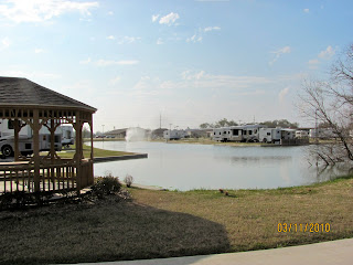
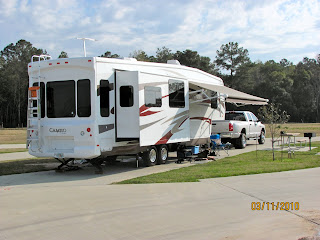
All in all it is a clean park @ $25 a day (with a Good Sam discount) 50 amps and full hook-ups including wifi. We picked a large pull through site near an open field for Maggie and Rico. We plan to stay at least through Monday. Joyce parked her car in an overflow parking space close by.
Okay so back to the mileage. My overhead indicated I was up to 10. 7 mpg over the 9.3 I started out with. Now I know the overhead computer reading isn't accurate and I'll need to figure out the actual mileage when I fill up. But the point is, slower is better and the higher rpm worked as well. I'm no expert, but I'm learning that with diesel engines, you need to keep the rpms up in the "sweet spot" so that the engine doesn't lug and waste fuel. I would prefer to tow @ 55 mph but that would be borderline dangerous on the interstate.
Edit: I fueled the truck and manually figured the fuel mileage at 10.5 m.p.g. I think that's pretty good for towing our heavy trailer.
We woke to a foggy wet morning. It had stormed a bit overnight. Our campsite and the campground in general was full of standing water. The ground had been saturated and there were puddles when we first got to Fontainebleau State Park a week ago. However, after this new rain it is much worse.
But for us its travel Day! We finished packing up and headed to the dump. Our sewer capacity holds us for over a week. The grey tank was full after 3 days and a couple of showers. I rolled over to the dump station and took care of business taking care to flush the tank with the hose at the dump station.
We headed west out of the park on 190 rolling through Mandeville and eventually to I-12 where we continued west. As you know, my truck is a 2009 Dodge with the 6.7L diesel and 4.10 differential. Once on the interstate, I set the 6 speed transmission to lock out 6th gear and put it into Tow Haul Mode. I set the cruise at 60 mph with my rpms at @2150. I noticed that my mileage began to climb overtime on the overhead from the 9.3 mpg from the previous tow. I had read on-line at a dodge forum that the best towing rpm when towing heavy is between 1800-2200. In addition much over 58 mph and the wind drag kills the mileage. Previously I was using 6th gear and traveling at 64 mph @ 1700 rpms. However, at that speed and rpm, I wasn't getting very good mileage per gallon. Also the transmission would shift down when hitting steep rolling hills.

The roads in Louisiana are rough. I-10 was no exception. We passed through Baton Rouge climbing the tall Horace Wilkinson Bridge over the Mississippi River. The trucks exhaust brake worked as advertised on the downside of this bridge. We drove over the 18 mile long Basin Bridge and traveled at the posted 55 mph for trucks. The Atchafalaya Basin Bridge is the 7th longest bridge in the world and the 6th longest over water. The bridge is located in Louisiana, USA and carries interstate 10 over the Atchafalaya Basin the bridge has a total length of 96,095 feet or 18.2 miles long. About 1/3 of the way across the bridge a group of troopers were running laser.


We climbed the tall steep Calcasieu River Bridge in Lake Charles with no problems. I'm a little concerned when I travel through tight areas such as a bridge with no shoulders. We only saw one rest stop on I-10 along our route, so we stopped after about 140 miles at a truck stop to give Maggie and Rico and us a break.
After just over 200 miles, we made it to A+Motel and RV Park a private park in Sulphur, Louisiana just west of Lake Charles and near the Texas border.

I had hoped to stay at Sam Houston Jones State Park, but a check of Reserve America indicated that park was booked for the weekend. So I had researched and found that A+ Motel and Rv Park got good reviews.

It's a new RV park with concrete slab roads and sites. The sites are close together with no shade.

However, the guests are all spread out. There's a large shallow concrete retention pond in the center of the RV park that rents as waterfront haaa!

All in all it is a clean park @ $25 a day (with a Good Sam discount) 50 amps and full hook-ups including wifi. We picked a large pull through site near an open field for Maggie and Rico. We plan to stay at least through Monday. Joyce parked her car in an overflow parking space close by.

Okay so back to the mileage. My overhead indicated I was up to 10. 7 mpg over the 9.3 I started out with. Now I know the overhead computer reading isn't accurate and I'll need to figure out the actual mileage when I fill up. But the point is, slower is better and the higher rpm worked as well. I'm no expert, but I'm learning that with diesel engines, you need to keep the rpms up in the "sweet spot" so that the engine doesn't lug and waste fuel. I would prefer to tow @ 55 mph but that would be borderline dangerous on the interstate.
Edit: I fueled the truck and manually figured the fuel mileage at 10.5 m.p.g. I think that's pretty good for towing our heavy trailer.
Subscribe to:
Posts (Atom)