Lake Mead N.R.A.

Lake Mead N.R.A.
READY TO ROLL!

Saturday, December 11, 2010

CAP Tour and Training the Interns

December 11, 2010. Bill Williams River NWR
The last few work days have been pretty busy. On Thursday we took an impromptu tour of the Central Arizona Project (CAP) pumping plant with the other volunteers and the interns. The pumping plant pumps out of the cove outside our campsite door. I wrote about the CAP in this September 22 post.
This CAP station pumps 3 acre feet of water a minute out of Lake Havasu and through one of the Buckskin Mountains into an open aqua duct flowing towards Phoenix and Tucson Arizona.
The plant operates 6 pumps. We were told that just one pump uses more electricity than Lake Havasu City on a hot summer day. All 6 pumps use more electricity than any other city or entity in Arizona. Much more than the Parker Dam can produce.
The tour in the 5 story reinforced concrete building was interesting although it was virtually impossible to hear what was being said due to the noise of the pumps. The entire building shakes just a bit from the vibration of the pumps.
Later in the day, the assistant refuge manager asked me to work with Hanna, our newest intern. She will be doing the hydrology field work (checking wells) in the refuge.  However, first she needed help in learning to hitch and unhitch the ATV trailer. After she felt comfortable with that task, I had her practice backing and parking the trailer in a set of cones. She had previously never done any of these tasks in her 22 years so it was a matter of getting her comfortable with the basics.

After lunch she trailered the ATV to the end of Planet Ranch Road and we took a ride on the ATV to inspect the Cohen Ranch Field. The route to the field was covered with water from the ever changing/moving shallow Bill Williams River.
At the field we discovered that some of the pipes from the solar powered pump had broken. The PVC gets very brittle in the hot sun and can easily break especially if under pressure. The pump is used to drip feed a number of Mesquite trees and other plants planted in the field as part of a restoration project.
Friday, we worked with both interns, Hanna and Mely putting up some Christmas decorations in the visitor center to include some outdoor lights on the gabled entrance. (I thought I was done with Christmas Lights since we sold our house!) Mely is the intern assigned to do education projects for the public on the refuge.
Afterwards Stan the Assistant Refuge Manager, asked Joyce and I to take the interns out into the refuge, show them around and get them accustomed to the Ranger ATV. (They will receive formal ATV training in the near future).


We left the refuge entering BLM land through the locked gate after a precipitous rocky climb.
We traveled over some steep and rocky ascents and descents as I gave them the chance to drive. They were somewhat reluctant to drive as perhaps they were outside their comfort level. This was the same area were the previous hydrologist intern, Nicky had taken us a couple of months ago (Exploring The Bill Williams River Refuge.)


We returned to the refuge staying on flat sandy ground of the washes and riverbeds where they enjoyed learning to operate the ATV. In the picture below you can see the Bill Williams River area with the yellowing Cottonwood Trees and Salt Cedar.

Interns: Mely and Hannah
We all made it back safely and both of the interns had a blast. Frankly so did Joyce and I. We've always enjoyed going out into the refuge. I'm sure we will be going back out soon to make repairs to the damaged irrigation.
We only have 3 official work days left before we move on December 20th.


Friday, December 3, 2010

Restocking an Endangered Fish, The Bonytail Chub

December 3, 2010. Bill Williams River National Wildlife Refuge
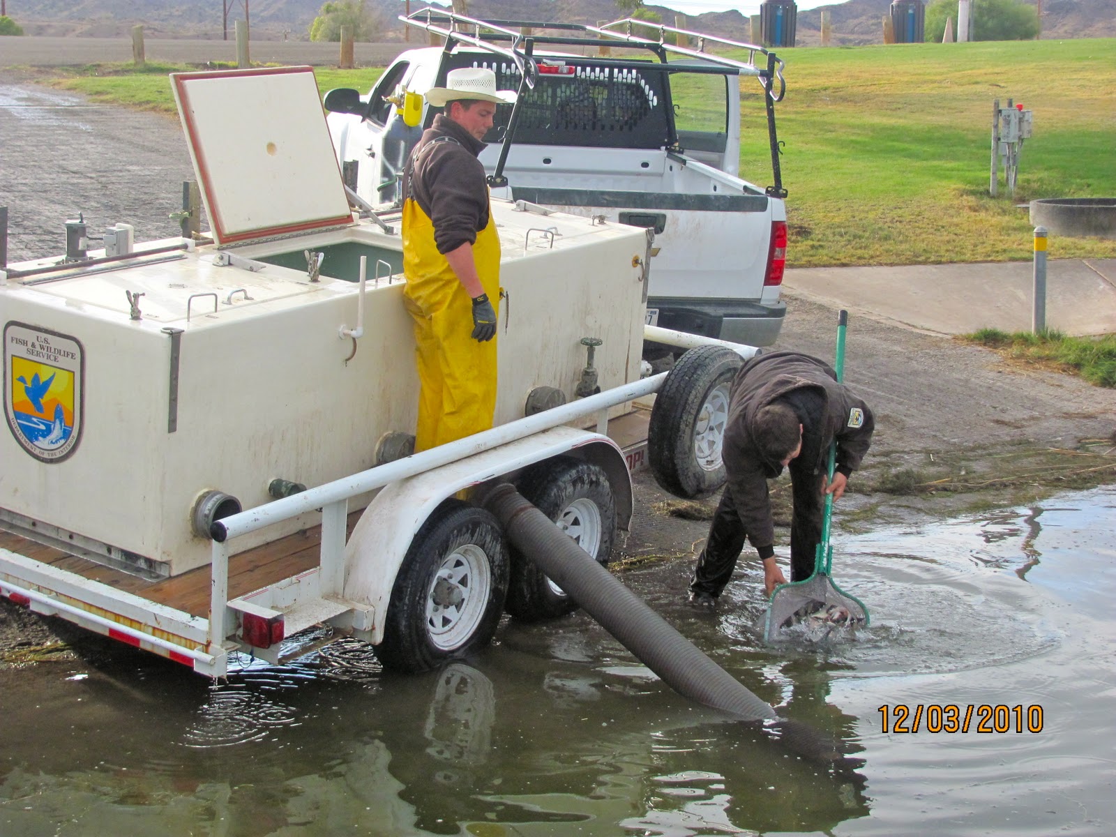
Today, Joyce and I had the opportunity to work with some U.S. Fish and Wildlife Fisheries Biologists releasing endangered Bonytail Chub into the Colorado River and Lake Havasu.
Endangered Status The Bonytail Chub is on the U.S. Endangered Species List. It is classified as endangered throughout its range in Arizona, California, Colorado, Nevada, and Utah. This fish lives in large, fast-flowing waterways of the Colorado River system, and the large-scale damming of the river has diminished available habitat. Water-management practices such as damming and channeling not only change the speed, location, and volume of flow, they change the temperature and the clarity of the water and block migration routes. Other threats to the Bonytail Chub have been the introduction of non-native fish that compete for food and habitat, and may prey on it or hybridize with it.
The BonyTail Chub were released in two locatons. The first location was La Paz County Park on BLM land on the Colorado River south of Parker Dam.
Bonytail Chub Description To 24" (61 cm). Moderately elongate; greenish-gray above, sides lighter, whitish below. Breeding males reddish-orange below and on paired fins. Head short; snout depressed, broadly rounded, usually not overhanging upper lip; hump on nape in adults. Fins large, slightly falcate; usually 10 dorsal fin rays; 10-11 anal fin rays; caudal peduncle very narrow; caudal fin deeply forked. 75-88 lateral line scales; scales embedded or absent on predorsal area, belly, and caudal peduncle.
These Bonytail Chub were raised by the fisheries in various ponds before being released. They are released into the Colorado River systems once a year at this time. At this location 900 fish were released into the river.
The Bonytail Chub is so endangered that some biologists would argue that they are genetically extinct as they have not been able to establish that any Bonytail Chubs alive today have not been reproduced and raised in hatcheries. They do not seem to be successfully reproducing and thriving in their native environments.
Endangered species
Any species which is in danger of extinction throughout all or a significant portion of its range. Aspecies whose numbers are so small that the species is at risk of extinction.Where the populationof a species is dangerously low, so much that their gene pool diversity is adversely affected while there is a risk of the species being wiped out all together, usually a consequence from humangain.

All of the Bonytail Chubs that were released have an identification type chip (similar to pet chips) embedded in their body. However to track the Bonytail Chub movements in the rivers and lakes some of those that are released have a tracking sensor surgically placed in their body. Here near the shore at our refuge, biologists were inserting the sensors in the abdomen of 20 select Bonytail Chub.

The Bonytail Chub are first anesthetized in a water solution.

The capsule shaped sensor below is inserted in a select Bonytail Chub.
It's not every day that I get to hold the most endangered fish in the Colorado River! Intentionally killing or molesting this fish could result in a $10K fine. This one has been anesthetized for surgery to implant the sensor above.
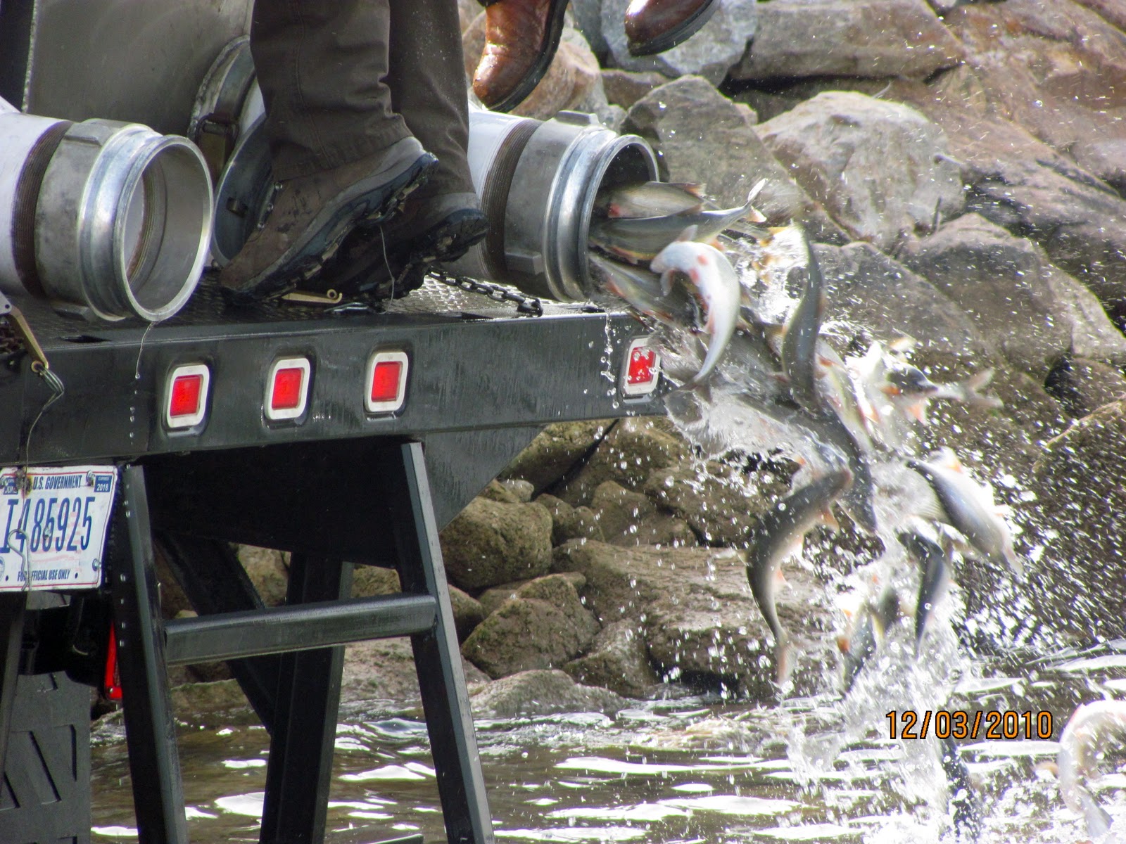
A large truck from the hatchery carrying 2100 Bonytail Chub arrived at our refuge to release it's cargo into Lake Havasu.
The fisheries personnel were sure to match the water temperatures of the holding tanks with the lake. In this case the water was about 57 degrees.
Not exactly a graceful exit!
Both the Razorback Sucker and the Bonytail Chub have trouble competing against introduced species in an environment in the Colorado river that has changed from a warm flowing turbulent river to a series of cool calm lakes. To protect these endangered species, water releases from dams are regulated to protect spawning areas. Ambitious stocking and habitat improvement programs as well as intense scientific study are aimed at restoring self sustaining populations wherever possible within their natural environment.
We enjoyed our opportunity to participate in this important attempt at saving the Bonytail Chub from extinction.

Thursday, December 2, 2010

Hike out on the Bill Williams River NWR

December 2, 2010. Bill Williams NWR
The last couple of Days we did some hiking off Planet Ranch Road within the refuge. 
Our dusty Rubi on Planet Ranch Rd.
Yesterday, we hiked a short distance past the slot canyon at the 1.5 mile marker on Planet Ranch Road. Our hike was short because we came across a barbed wired fence. Today we went back and finished the hike after learning that the fence was left over from when cattle used to roam around Planet Ranch Road. We bypassed the fence today by hugging the canyon wall and climbing over a small bluff. Looking back through the slot canyon you can see the hole in the rock below.

Once past the slot canyon walking in the direction of the Bill Williams River, the fauna gets thick with cactus, Mesquite, Palo Verde and Creosote. We came across a number of very tall Saguaro Cactus.


The magnificent Saguaro Cactus, the state flower of Arizona, is composed of a tall, thick, fluted, columnar stem, 18 to 24 inches in diameter, often with several large branches (arms) curving upward in the most distinctive conformation of all Southwestern cacti.

The skin is smooth and waxy, the trunk and stems have stout, 2-inch spines clustered on their ribs. When water is absorbed , the outer pulp of the Saguaro can expand like an accordion, increasing the diameter of the stem and, in this way, can increase its weight by up to a ton
.

The Saguaro has a surprisingly shallow root system , considering its great height and weight. It is supported by a tap root that is only a pad about 3 feet long, as well as numerous stout roots no deeper than a foot, emanating radially from its base. More smaller roots run radially to a distance equal to the height of the Saguaro. These roots wrap about rocks providing adequate anchorage from winds across the rocky bajadas.


Joyce enjoyed the hike!
After completing the hike through the slot canyon and along the river, we decided to drive to the end of Planet Ranch Road and try one of the trails that lead away from the river into the desert toward the Buckskin Mountains.
Buckskin Mountains is a mountain range in La Paz County in the state of Arizona (AZ). Buckskin Mountains climbs to 1,496 feet (455.98 meters) above sea level. Buckskin Mountains is located at latitude - longitude coordinates (also called lat - long coordinates or GPS coordinates) of N 34.155298 and W -113.830771.
A large wash surrounded by the Buckskin Mountains
We enjoyed our hikes and decided to call it a day as the shadows were getting long! The contrast between the desert and the riparian area around the river is amazing.
Tomorrow we are back to our 3 day work/ volunteer schedule here at the refuge so we'll see what's new!