Lake Mead N.R.A.

Lake Mead N.R.A.
READY TO ROLL!
Showing posts with label Usery Mtn Park. Show all posts

Monday, March 5, 2012

Usery Mountain Regional Park

March 4, 2012 Travel Day to Usery Mountain Regional Park Mesa, AZ.
I'm always a little uneasy when we start traveling especially after sitting in the same spot for the past 4 months. But this was a good travel day. We got rolling around 8:30 after saying goodbyes to fellow volunteers and campers in our cozy little volunteer campground.  Dara and her husband Marc had come over the night before with their son Noah to say their goodbyes. 
After about hundred miles, I again began to feel comfortable. Paul and Paula were leading us down AZ Hwy 93 and Joyce was bringing up the rear. We made one stop on the 300 plus mile trip at a roadside picnic table. Although it was a long day we thankfully arrived at our campsites in Usery Mountain Regional Park without incident. This has always been one of our favorite parks and its very close to my father's home. The park is full to capacity with some campers staying in the over-flow lot. We had reserved site 67 and Paul and Paula site 66.

We paid $75 for the site for three nights plus a $8 online registration fee. We wanted to stay longer but the time frame just wasn't available at this very popular winter park.
Site 67


Karen and my father prepared a late dinner for all of us at their place. We were happy and surprised to see my Cousin Teri and her husband Rick join us for dinner. After catching up we finally got home and into bed about 9 pm. We were all exhausted from our first travel day in months! Tomorrow is expected to be exceptionally warm at 87 degrees. Glad we have a new air conditioner!
Published with Blogger-droid v2.0.3

Sunday, January 9, 2011

Visiting with Friends from our New Life Style

January 9, 2011 Usery Mountain Regional Park.

Another Beautiful Sunset
Yesterday, we invited some friends Betty and Dale to come visit with us. We had met Betty and Dale last spring at Cottonwood Creek RV Park. We had made an instant connection and enjoyed their company. They are staying in a RV park in Goodyear on the west side of Phoenix. They RV in the winter months to escape the winter weather of the Midwest. Betty and Dale arrived around noon and after catching up we enjoyed a wonderful lunch of chili with chicken sandwiches. Betty brought a wonderful lemon pie. 
We took a short hike around the park showing off it's many varieties of cactus and the wonderful scenic vistas. Later we took a ride in the Jeep out towards the Superstition Mountains.  We took them down the dirt road to the First Water Trail Head, where we had previously done a hike. At the trail head we discovered the Maricopa County Sheriff's Office (MCSO) had a Search and Rescue Party that was apparently wrapping up their operation. I captured this picture of their helo taking off.
Today we learned that they had found the remains of lost hikers/ explorers. Ironically from the same area where we had nearly become lost.

MCSO Finds Remains of 2 People

Updated: Saturday, 08 Jan 2011, 5:27 PM MST
Published : Saturday, 08 Jan 2011, 4:31 PM MST
MESA - The Maricopa County Sherriff’s Office has found remains they believe are from two people in the Superstition Mountains Saturday afternoon.
The MCSO mountain rescue team and helicopter spent most of Saturday searching for the remains that were found by a man hiking on Friday night.
The man told MCSO that he thought they might belong to the three hikers from Utah who went missing in July, according to MCSO spokesman Jeff Sprong.
Sprong said officials will be checking to see if they are the remains of two of the hikers.
He said because of the conditions of the remains, the Medical Examiners Office will be trying to identify them. It was unknown how long it will take to identify the subjects.
Related Story:
Sheriff Ends Search for Missing Utah Hikers

After witnessing the activity at the trail head, we took a ride and stopped along the way to take photos of the Superstition Mountains.
Dale, Betty and Joyce
We really enjoyed visiting with Dale and Betty and we sure hope to see them again sometime down the road. Who knows, maybe someday we will stop and visit them on their farm in Nebraska.
Today, we took a ride with my Father and Karen out to the Gold Canyon community to meet some of their friends and have lunch at the country club. We had a great time and enjoyed seeing the area and the company.


Friday, January 7, 2011

Our new site at Usery Mtn. Regional Park and a short hike.

January 7th, 2010 Usery Mountain Regional Park.
House Finch feasting on a half orange
As you know, we had to move sites per the park's rules after the initial 14 days in one site. So on the 4th we moved from site 9 to site 30. It's on the outer loop but an inside site with a great rear view of Pass Mountain.
Site 30
Side yard with fire pit.
Rear window view.

After our last dramatic hike where we felt a bit lost, I did some thinking about what kind of gear we should carry with us. So the next day at Walmart we picked up a first aid kit, some portable foil emergency blankets, plastic ponchos and a waterproof match stick holder. Back at home I packed both our packs with the above gear including a small flashlight for each and a pair of leather work gloves. In my pack I also packed a small wool blanket extra batteries and fire starter. I've basically determined that my pack may be too small with the added gear for hiking in the desolate backcountry mountains. 
I also purchased a Bushnell Original Back Track from Sam's Club. 


GPS MADE SIMPLE!

BackTrack utilizes GPS technology in its most basic format, BackTrack has only two buttons and stores up to three locations – just mark it and forget it until it’s time to return. At the end of the day, select your location and the BackTrack displays direction and distance to travel. Use it to find your car in a crowded parking lot, your treestand or the trailhead, even to rendezvous with your group. It’s extremely compact and stows conveniently in your pocket, pack or purse.

It's a very simple GPS that can mark up to three locations at a time i.e. you car. The Back Track then gives you a directional arrow and distance (as a bird flies) to your car or whatever location you set into the Back Track. At $39 it was certainly cheaper and less complicated than a full scale portable GPS.
I did a short hike today down to the Salt River in the Tonto National Forest to test the Back Track.
The Bushnell Back Track so far works as advertised. I obtained a satellite signal after getting out and set the Back Track to the location of my vehicle. The unit powers off after a short period of inactivity. When you turn it back on it immediately obtains a satellite signal and picks up in the mode from which it turned off. It measures the distance initially in yards and then eventually in miles and tenths of a mile. Right now I'm very satisfied with it. 

Monday, January 3, 2011

Hike at First Water Trail Head in the Superstition Mountains

January 3, 2011 Usery Mountain Regional Park.
You may have noticed that we started a Facebook page for our blog. I'll be posting more pictures on the Facebook site as it's faster to load them. In addition there will be more timely short updates. Joyce will be helping me with monitoring the Facebook page. Please feel free to write on the wall. In the near future perhaps we will have some "Discussions" on the Facebook page as I become more familiar with it.
Well, today we were supposed to move campsites to be in compliance with the park's 14 day rule. We found a site we wanted and went to the gate house to register. Their information indicated the site would be vacated by noon so we paid for a week at the site.  So at some point we drove by the site to check on the status of the occupants to see if they were preparing to move. It turns out they had a new tag posted on their site indicating they wouldn't be leaving till 1-4-11.  Long story short, they had renewed via the "iron ranger" and after checking back with the registration desk we ended up staying in our current site at least till tomorrow. The volunteers running the registration desk were very apologetic for the mix-up. So tomorrow morning we will pull out to dump our tanks and move to another site.
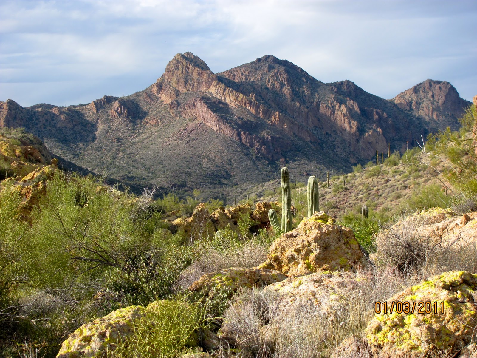
So, with the morning shot, we decided to take an afternoon hike in the Superstition Mountains. We drove east through Apache Junction before turning Northeast on Hwy. 88. turning at a sign for First Water Trail Head on FR-78.

The turn onto FR-78 to the First Water Trailhead in the Superstition Mountain Wilderness is 0.3 miles past Lost Dutchman State Park on the Apache Trail (SR-88). FR-78 is a gravel road with several unbridged crossings but it's almost always passable by passenger cars. The exception would be during or after a rain. This is one of the two most popular trailheads in the Superstition Wilderness--the other being the Peralta Trailhead. The main trails leaving the trailhead are the Dutchman Trail and the Second Water Trail.
In addition to the trails out of the First Water Trailhead, this road is also used for access to: the Crosscut Trail, the Massacre Falls Trail, the First Water Horse Lot (Overflow lot), Hackberry Spring, and First Water Ranch. There are vault toilets at the First Water Trailhead and at the First Water Horse Lot


Near the end of the FR-78 (dirt road) is the trail head.
Starting out on the Lost Dutchman Trail.


The trails were not very well marked and we didn't see any maps of the area at the trail head. By this point below, we were pretty much lost!
I had a compass and a general heading for the start of the trail head but that's it. And the general heading was over hill, mesa, stream and mountain. Not exactly a direct route.
It was just after 3:00 so I knew we had a couple hours of daylight. However the low sun and the clouds made it seem later in the day.


We decided to continue moving forward following a trail. A trail that seemed at times to be frequented by equestrians as evidenced by the occasional pile of horse manure.
We seemed to pass over the same or similar creek beds along the trail as we were becoming increasingly uneasy about our apparent inability to find our way! Finally we saw what looked like a hut in the distance. We hiked toward it and what we thought was a hut was a tin roof covered stable. Thankfully there was a man and woman there who helped us with directions back to the trail head. 
Covered Horse Stable
It turns out we had been within a couple miles of the trail head and once out of the valley they called "Second Water Valley". We were back on the dirt road FR-78 and had only a short hike to the end of the road and the trail head. We got back just short of 3 hours.
Back home, I did some "Google" searches and found this very good site of the trails: Hike Arizona. Best I could tell we did a version of the Hack Berry Spring Loop. 
This hike has made us realize that really should carry a GPS or some type of directional finder other than a compass. It's rare that we ever have a map of the areas we hike. We took off on this trail cold without any information before hand. Perhaps not the best way to go!
Having said all that, It was a beautiful hike with lots of beautiful mountain scenery.

Friday, December 31, 2010

Happy New Year!

December 31, 2010. Usery Mountain Regional Park
House Finches on Saguaro Cactus
On this New Year’s Eve, we hope everyone has a Happy and Prosperous New year!
The last few days have been spent with my Father and Karen mixed with hanging out in the park with the dogs. A few nights ago we shared a nice campfire at our campsite. It was a cool evening with no wind which made it perfect for the fire. 
Desert sunset from our campsite.
On Wednesday we drove to the local Verizon Store to update our phones. Our phones were two years old and showing their age.  At one point, we had discussed getting a “smart phone” for Joyce to have internet on the road and because she’s always checking her Face Book account. However, we had decided against it due to the anticipated additional monthly costs.
At the Verizon Store we were helped by a very good saleswoman, Lesli who really knew their products and phone plans. Lesli showed us how we were overpaying on our current plans. The plan for our 5 gigs of broadband data on the MiFi had decreased by $10 a month. She said it looked like we were using only 2 gigs a month and they have a 3 gig plan that would save us another $15 a month, but we decided to keep our 5 gigs and just take the $10 savings. Lesli checked our phone records to determine that we averaged less than 200 minutes a month well below our 1400 minute plan. So, she reduced us to a 700 minute plan saving an additional $20. With the savings, we again began considering a “smart phone” for Joyce.  After checking out the Droid phones, Joyce settled on a Droid X. Her phone is like a mini IPad that makes phone calls!
Droid X and Casio Ravine
I picked up a rugged phone (with no broadband service) called the Casio Ravine. So with the monthly service savings, the cost of unlimited internet on Joyce’s Droid was a wash making our monthly phone bill the same. So aside from having to pay the upfront cost of both phones we made out pretty good. After rebates, my phone will be free and Joyce’s will be $199.
After getting our phones we set off in the rain to a theater to watch the newly released movie, True Grit. We missed the 1:30 showing and walked around the shopping plaza as Joyce played with her new phone till the 3:00 show. The movie itself was very good and worth watching if you like “westerns”.
Lately, it seems we’ve done a lot of driving and shopping. Yesterday we visited both Sam’s Club and Costco just because, we like to look around and we were killing time staying inside from the miserable cold outside. I don’t mind the cold as long as the sun comes out. However, it’s been cloudy and cold. In fact yesterday we saw snowflakes here in Mesa and the local news captured pictures of a light dusting of snow that stuck for a few hours in the local area. 
The low last night was below freezing. I disconnected the rig’s water hose last night and let the campsite spicket drip. We used the rig’s water tank and pump for water till late this morning. I turned on a 60 watt drop light in the basement next to the water tank and pump to help keep the basement warm. Our basement and tanks are heated but only if I run the furnace. We had two ceramic heaters running all night but we were still cold. When we woke this morning it was 60 degrees inside and 48 in the basement. I turned on the furnace this morning to chase away the chill. Outside the water in the dog’s water bowl froze solid! It’s suppose to be colder tonight with temperatures dipping into the 20’s! We don’t have any plans for “ringing in the New Year” so we will see what happens.
As some readers have suggested, we can in fact stay here at Usery Mountain Regional Park beyond the 14 day limit. It just requires that we move out of our current site and into another available site. We are undecided on whether or not we will move to another site and stay longer or just press on towards Tucson on Monday.
Happy New Year!

Sunday, December 26, 2010

Relaxing the Day After Christmas

December 26, 2010 Usery Mountain Regional Park.
Pass Mountain
We hope everyone had a Very Merry Christmas. On Christmas Eve we drove to Cousin Raymond's House for a family get together and some traditional tamales! We spent Christmas morning at my Father and Karen's home in Mesa. My Father prepared an outstanding breakfast with eggs, potatoes, bacon and tamales. Afterwards, we traveled 50 miles to my Cousin Terry and Rick's home in Glendale, Az where we ate more tamales! We had a great time visiting with relatives, enjoying the holiday and eating too much.
Today was a day to relax and decompress. Joyce went to a few stores this morning with Karen to return a few items and no doubt buy some more! I stayed at home with Maggie and Rico enjoying the cool weather.
Maggie
Rico
Later in the day I took a short walk along a wash in the back of our campground site. There are so many large and beautiful Saguaro Cactus in the park.
Large Cholla in the foreground.
Pass Mountain in the distance.
Phoenix to the West.
Relaxing in the mild climate of the Sonoran Desert. Does it get any better than this? We intend to find out as we continue to travel next year. Stopping to enjoy one state at a time.

Friday, December 24, 2010

Wind Cave Hike in Usery Mountain Regional Park, Mesa

December 24, 2010 Usery Mountain Regional Park, Mesa Az.
Located on the Valley’s east side, this park takes in 3,648 acres set at the western end of the Goldfield Mountains, adjacent to the Tonto National Forest. 
The last few days since arriving have been filled with last minute Christmas shopping and visiting with my Father and Karen. We've done a lot of driving to and fro and I'm sure we will do a lot more as we plan to visit relatives throughout the Phoenix Valley.
We had some rainy cloudy weather as the system that devastated California earlier in the week, passed over the Valley. I actually was looking forward to the rain to wash off the dust on the roof of the rig!
View on the door side of our rig.
Yesterday, it was still cloudy and cool with a forecasted high of 65 but the weather was clearing. We decided on doing the most popular hike in Usery Mountain Regional Park, The Wind Cave Hike.
The park contains a large variety of plants and animals that call the lower Sonoran Desert home. Along the most popular feature of the park, the Wind Cave Trail, water seeps from the roof of the alcove to support hanging gardens of Rock Daisy. The Wind Cave is formed at the boundary between the volcanic tuff and granite on Pass Mountain. Breathtaking views from this 2,840-foot elevation are offered to all visitors
Beginning the hike.
Pass Mountain
The trail was washed out in many areas no doubt, due to the recent rain fall. Much of the trail up the mountain required stepping over large fallen rocks which made it more challenging.
One of the smoothest sections of the trail
Near the top
The Wind Cave is basically a large hollow in the side of the mountain. I didn't include a picture as there were other people in the photos I took. The hike seemed to be very popular. We found a secluded perch near the cave where we sat and enjoyed our snack and the beautiful view of the valley.
Perched by the Wind Cave.
View looking South.
Our campground in the distance looking West.
While seated from my perch on Pass Mountain, I played with my Canon camera using the 40x zoom to capture the picture below of our campsite. You can see our silver Dodge and the Cameo behind it.
Our site from afar!
We climbed back down returning to the Jeep after our two-hour trek which is the average according to the park information on the hike.
We like Usery Mountain Regional Park especially the campground. The views are fantastic. There is a shooting range in the park and I can hear the target shooting when outside but it's not annoying. Maggie and Rico continue to have encounters with the cactus spines on the ground from time to time so we have to be cautious. There is no sewer hook-up so we have to be frugal with water. I have to empty my 18 gallon grey tote everyday. I don't want to fill my grey (rig) tank as then it can be messy draining it into the grey tote. But that's just me!
We are considering staying longer in the valley but it's difficult to find a park that isn't 55 plus. So we may just stay here for another week. You may only stay at Usery Mountain Regional Park for 14 days.

Monday, May 10, 2010

Relaxing with Family and Enjoying the Scenery


Painted Mountain (you can see our red car in the foreground)

May 9, 2010.
The last few days have been a whirlwind. We arrived on Friday, May 7 and got set up before going to my father and Karen's place in Mesa for dinner. On Saturday, we went to the home of my cousin Terri and her husband Rick. They put on a 75th Birthday Bash in their back yard for their mother, mi Tia Lilly. The mariachis played for at least two hours and were very good! In the photo below mi Tia Lilly is seated at the table in the purple top. The party was great and it gave us a chance to see a lot of my family that I had not seen in years. Terri and Rick have a beautiful home and organized a wonderful party.


The next day we lounged around the rig as temperatures climbed to 96 degrees. However, we had a good breeze and it wasn't too bad. Later my father and Karen came over for dinner. 


This morning, I took a ride on my bike around the park and took these pictures of some of the cacti.


Some of the Saguaro Cacti are still in bloom and the birds are nesting in the cacti.


With the right growing conditions, it is estimated that saguaros can live to be as much as 150-200 years old.

Saguaro are very slow growing cactus. A 10 year old plant might only be 1.5 inches tall. Saguaro can grow to be between 40-60 feet tall (12-18m). When rain is plentiful and the saguaro is fully hydrated it can weigh between 3200-4800 pounds


I attempted to ride some of the trails around the park, but some were too overgrown to ride safely. I came across what I believe is a large Diamond Cholla still in bloom.


The Chain FruiCholla or Jumping Cholla are abundant here in the park. This one has an active bird nest in the center of it. 


While on a walk in the park, Joyce had come across a piece of Cholla cactus in the street and tried to kick it to the side of the road. Naturally, it impaled her sandals just missing her foot. I had to pry it off with a pocket knife. Our camping neighbors discovered a 4 foot rattlesnake in the back of their campsite and chased it off into the brush. We have to be very cautious with the dogs because of the cactus and the critters.

But I gotta tell ya, it's beautiful out here in the Sonoran Desert surrounded by the Superstition Mountains!