Lake Mead N.R.A.

Lake Mead N.R.A.
READY TO ROLL!
Showing posts with label Monticello. Show all posts

Monday, August 2, 2010

Moab, Utah

August 2, 2010.
The last couple days, we were besieged with rain and thus, stayed around the campground. Needless to say, we developed a good case of cabin fever. So, today we took a drive out to Moab, Ut. @ 100 miles round trip. On the way we stopped at Hole N' The Rock off hwy 191. 
It's conveniently located about half way between where we are staying in Monticello and Moab. It's a cute little tourist stop with at least three souvenir shops and lots of interesting things to see.
Joyce posed in front of a bull, one of many art statutes in the yard.

We parked downtown in Moab and walked around the town. You can see our truck parked along the side of the road in the picture below. We took the truck because we've put almost 2400 miles on the Jeep since buying it in June.
Moab is a an interesting, modern town that obviously thrives on tourism. There are a plethora of souvenir and T-shirt shops along Main Street.
The temperature in Moab was pushing 90 +. In comparison it was in the upper 70's when we left Monticello. We visited the visitor center and could over hear the employees warning visitors of the dangers associated with heat from hiking and biking during this time of the year out on the many trails. Afterwards Joyce and I discussed it and we decided that we would likely return to Moab in the late winter or early spring months to take advantage of the excellent hiking and biking opportunities.
We strolled the shops along Main Street and then stopped at a local cafe for lunch. By the time we were ready to head home, the storm clouds had built up to the south in the direction we would be headed.
I loved the silhouette of the mountains to the west of Moab.
Fortunately, most of the rain moved off as we drove south. We pulled off Hwy. 191 to photograph the Wilson Arch on the way home.
Wilson Arch, also known as Wilson's Arch, is a natural sandstone arch in southeastern Utah along U.S. Route 191 located 24 miles south of Moab. It has a span of 91 feet and height of 46 feet.[1] It is visible from the road to the east where there are turnouts with interpretive signs. The elevation of Wilson Arch is about 6150 ft.[2]
According to the sign at the pulloff near the arch:
"Wilson Arch was named after Joe Wilson, a local pioneer who had a cabin nearby in Dry Valley. This formation is known as Entrada Sandstone. Over time superficial cracks, joints, and folds of these layers were saturated with water. Ice formed in the fissures, melted under extreme desert heat, and winds cleaned out the loose particles. A series of free-standing fins remained. Wind and water attacked these fins until, in some, cementing material gave way and chunks of rock tumbled out. Many damaged fins collapsed like the one to the right of Wilson Arch. Others, with the right degree of hardness survived despite their missing middles like Wilson Arch."[3]

Back home we made some final preparations to move on tomorrow. 


Saturday, July 31, 2010

ABAJO MOUNTAIN AND CANYON LANDS NATIONAL PARK

July 30, 2010.
The day started off a bit overcast, which may have caused us to sleep in a little too late! Undecided about what to do today, I talked with the park owner. He's a deputy sheriff for San Juan County. He suggested that we take a scenic drive over The Abajo Mountains
It was about noon by the time we were ready to go anywhere. We drove into town and followed the directions I was given to Abajo Drive. Although the steep climb over the mountains is paved, we decided to venture off-road for a while...because we can!
We saw several deer along the dirt roads. The vistas were spectacular.
The Abajo Mountains, also called the Blue Mountains, are a small mountain range west of Monticello, Utah, south of Canyonlands National Park and north of Blanding, Utah. The mountain range is located within the Manti-La Sal National Forest. The highest peak within the range is Abajo Peak at 11,360 feet (3,463 m)
We only climbed to about 8500 ft. but we could see Canyon Lands in the distance.
After descending down the mountain on the opposite side, we discovered we were only 20 miles from Canyonlands National Park so, we decided to drive over to the park. The first stop along the way was a historic site known as Newspaper Rock. (Click on the picture below to expand the picture and read about the history).
With only a 3 ft chain link fence around the border of the rock, we were able to walk right up to the petroglyphs.
After viewing Newspaper Rock, we continued the long but breathtaking drive towards the entrance to Canyonlands National Park (Needles District).
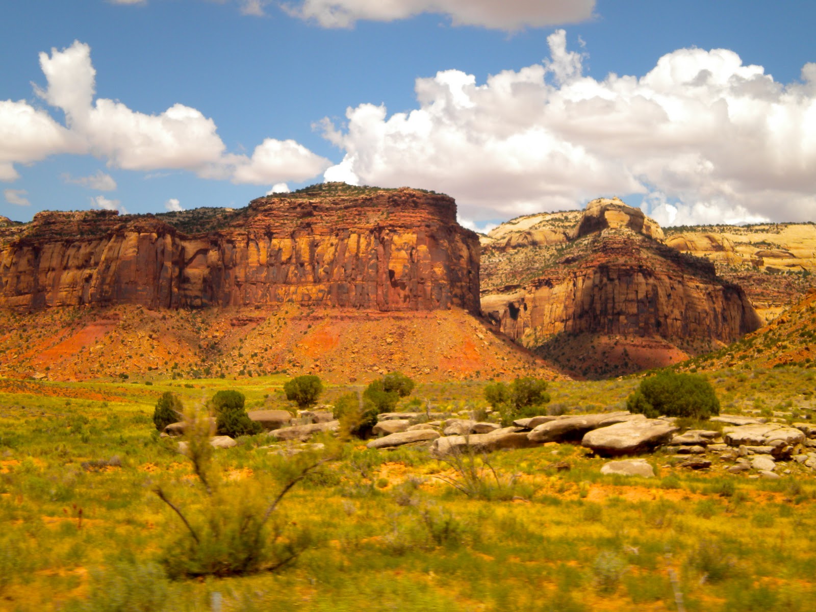
Canyonlands preserves an immense wilderness of rock at the heart of the Colorado Plateau. Water and gravity have been the prime architects of this land, cutting flat layers of sedimentary rock into hundreds of colorful canyons, mesas, buttes, fins, arches and spires. At center stage are two great canyons, those carved by the Green and Colorado rivers. Surround the rivers are vast and very different regions of the park: to the north, Island in the Sky; to the west, the Maze; and to the east, the Needles. The areas share a common primitive spirit and wild desert atmosphere. Each also offers its own special rewards. 
Few people were familiar with these remote lands and rivers when the park was established in 1964. Prehistoric Native Americans, cowboys, river explorers and uranium prospectors had dared to enter this rugged corner of south-eastern Utah, but few others did. To a large degree, Canyonlands remains untrammeled today. Its roads are mostly unpaved, its trails primitive, its rivers free-flowing. Throughout its 527 square miles roam desert bighorn sheep, coyotes and other animals native to this land. Canyonlands is wild America.
We were traveling in the Needles District.

The rugged canyons of what is now Canyonlands National Park have witnessed many human events since the earliest Americans. The Paleo-Indians entered the region around 10,000 years ago. The tides of human occupation have ebbed and flowed in concert with the availability of and demand for the various resources the canyon country has to offer.
The first people known to inhabit Canyonlands were the Archaic hunter-gatherers, wandered the area 2,000 to 10,000 years ago in search of large game animals and edible plants. They who lived in the open or camped under overhangs, leaving behind such artifacts as projectile points, atlatls or spear throwers, fire hearths, and ghost-like pictographs.


Most cliffs of canyonlands show classic profiles which can be seen throughout the southwest. Some of Canyonlands' rocks are massive layers of uniform sand which have become cemented. They are the cliff formers such as the Wingate and Cedar Mesa Sandstones. Gravity is an important partner, contributing to erosion as much as the infrequent rains. The softer, underlying rock layers erode more quickly. This undercuts the harder upper layers and they break off in huge slabs. Sometimes they form beautiful arched alcoves and, more frequently, the falling rock leaves vertical cliffs.

Canyonlands is located within a geologic region called the Colorado Plateau. It is a great section of continental crust that has endured millions of years of rock building and erosion.
Advancing and retreating oceans left thick deposits of beach sands and marine limestones. Great river systems moved tons of sediment from ancient eroding mountain ranges such as the Ancestral Rockies (forerunners of today's Rocky Mountains) and deposited that sediment in low-lying areas. Buried sediment became solid rock as pressure from overlying layers and filtering water cemented them.
After millions of years of predominantly rock-building processes, the erosion that continues today began. Roughly 10 million years ago, plates in the Earth's crust moved in such a way that the western edge of the continent began to rise. The slowly rising land mass, including the Colorado Plateau, became higher and therefore more susceptible to erosion Newly elevated highlands captured rain and snowfall and gave birth to the Colorado River system. The uplifting land caused rivers to down-cut more rapidly, entrenching themselves in solid rock. The results are the 2,000 foot deep canyons of the Colorado and Green Rivers cutting through the heart of Canyonlands.


The origins of the thousands of small canyons found in the area may be puzzling at first glance. Most of the year, time seems to stand still and the process of erosion is imperceptible. To witness the occasional rock fall or landslide is exceptional luck. But some of the erosive processes are sudden and violent. Sparse vegetation and an abundance of exposed rock make Canyonlands especially vulnerable to flash flooding. Thunderstorms drop huge amounts of rain locally. With little soil and vegetation to hold the water, runoff is fast. It quickly collects in gullies and small washes, magnifying its power as water funnels into the canyons. The erosive power of the debris and sediment-laden water is tremendous. Flash floods are continually scouring and deepening the canyons.
It was hot in the Canyon Lands during our visit with temperatures in the mid 90's. Usually not bad but with the monsoon season in full bloom it was also a bit humid...though not Florida humid! We did a little hiking around the overlooks and were in awe of the deafening silence. You know that quiet ringing you get in your ears when there's nothing to hear...awesome! The rocks themselves have a sandpaper texture to them making them very grippy and easy to walk on.
As we left the park, we discussed our original plan to return and do some longer hikes. Ultimately we decided against returning due to the long drive to get there (close to 100 miles round trip) coupled with the heat. We felt we had captured the essence of the park and returning this trip wasn't something we both wanted to do. However, I would highly recommend a visit if you are in the area.


Friday, July 30, 2010

Back to Colorado for Groceries

July 29, 2010.
We woke to an overcast cool morning with a high expected of 75 and a good chance of rain.
Due to poor planning we arrived in Monticello, Utah with few groceries. Joyce had checked out the small grocery in town and was not satisfied. So, after talking with some locals we decided the best option was to head back into Colorado to the closest Walmart in Cortez about 56 miles one way!
We had never been to Cortez and it looked like it was going to rain today so we thought it was as good a day as any to make the long trip. The road out was full of hills dipping in and out of big swells across farming land. It was a nice ride.
We made it to the SuperWalmart, made our purchases and got home without incident. About an hour after getting home it began to rain and continued raining till after dark.
All is well, just another day in the life...

Wednesday, July 28, 2010

Mountain View RV Park, Monticello, Utah

July 28, 2010.
So, I said in the last post, I would post some pictures of Mountain View RV Park and provide some more details.  
The only information I had on this park was from what I read on the website RV Park Reviews and from the Mountain View RV Park. I knew from calling ahead that with tax it would be $21.04 per day so I didn't have high expectations. However, the location in Utah and near Canyon Lands National Park, Moab and Monument Valley made it appealing. More importantly its at 7900 ft. and cool!
When we pulled in (after driving through town) Joyce immediately didn't like the park as it is a bit tight. However, we've been in tighter spots and paid a lot more. Of course the other reason is that there isn't any real shopping to speak of in Monticello. In fact the closest grocery store is 24 miles away.
We decided (with a little persuasion) to stay for a week as planned. They have about four or five 50 amp sites however, they are gravel sites with no grass or trees. So I took a 30 amp pull-through for the shade.
The park fills fast with folks passing through the area. It's located right off Hwy 191 so it's a little noisy with traffic. However, it seems to be quiet at night.
This morning we rode our bikes into town. Below is a picture of the San Juan County Court House.
We did some window shopping and checked out the few shops along main street.
We stopped for a late pizza lunch and then took our time riding back to the campground. There's not a whole lot to see in the town of Monticello.
Later after dinner, we took Maggie and Rico for a walk in town as we enjoyed the cool evening.

Tuesday, July 27, 2010

Travel Day to Monticello, Utah

July 27, 2010.
Today was a travel day into Utah specifically, Monticello Utah. Our destination was Mountain View RV Park. Monticello is about 50 miles south of Moab but at 7900 ft. it's cooler than Moab which has been experiencing temperatures over 100.
We got loaded hitched and ready to go by 9:00. Actually we did a lot of packing and cleaning yesterday.


The route took us up and down steep mountains between Ridgeway and Telluride.

We traveled along a beautiful winding red rock river gorge.
Out on the high plains we were still experiencing steep grades and rougher roads.

We tend to take the roads less traveled which is sometimes both good and bad. Some of our routes and particularly the section over Hwy 141 had some really steep sections with 20 mph hair pin turns.
You can see the clouds were building throughout the day as we entered Utah.
Descending into the town of Monticello, we could see it was raining on the Abajo Mountains.
Monticello is packed full of Old American West history.  In the 1800's so many fugitives fled to Monticello to escape the hand of the law in the isolated mountains and canyons, that it became known as the Outlaw Trail.  Monticello offers breathtaking views, serene wildlife, and fabulous fun.  

We made it to Mountain View RV Park and got set up before the rain caught up to us. It was a cold rain which quickly brought the temperature down to 68 degrees. Mountain View RV Park is a small private park in Monticello. The sites are tight but shady. I wanted shade so we had to take a 30 amp site with full hook-up.
I'll post pictures and more about the campground in my next post.